


How nitrogen finds its way into surface water
The Nature Conservancy released a report last week on the various ways nitrogen finds its way from the air and land and into surface waters throughout the Peconic Estuary.
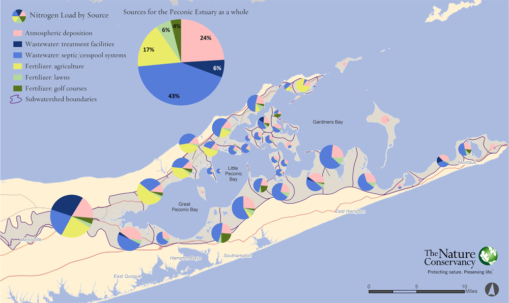
The report’s data shows that causes of nitrogen pollution vary significantly across the East End.
In many parts of the estuary, as suspected by researchers and environmental experts, septic systems were found to be the single largest single source of nitrogen, releasing 49.6 percent of the total amount entering Peconic waters. Other sources studied, referred to as “inputs,” included fertilizer from agriculture, lawns and golf courses, which accounted for 26.4 percent, and atmospheric deposits, which were found to contribute 24 percent, according to the overall figures.
- SEE FULL REPORT ON PAGE 2
But septic systems weren’t the leading source of nitrogen sources in all areas of the estuary.
The study identified agricultural fertilizer as the No. 1 source of nitrogen pollution in areas of the Great Peconic Bay and Little Peconic Bay on the North Fork’s southern shore, accounting for more than half the total there, as well as around Long Beach Bay in Orient, where it was found responsible for 77 percent.
“We see in the report that the North Fork is certainly the outlier when looking around the rest of Suffolk County,” said Christopher Clapp, a biologist with The Nature Conservancy, an international nonprofit environmental group with offices on the North Fork and elsewhere on Long Island.
In other parts of Suffolk County, the majority of the nitrogen is attributed to septic systems — with measurements of up to 70 percent, he explained, referring to countywide data.
“Along the North Fork and particularly the central part of the North Fork, because it is such an agricultural region, the nitrogen inputs from agriculture really do dominate the inputs,” he said.
Mr. Clapp said researchers “tried to be as fair as humanly possible to the agricultural community by including them in the process.”
Stephen Lloyd, a conservation information manager for The Nature Conservancy who authored the study, said he worked with representatives from Cornell Cooperative Extension of Suffolk County’s Agricultural Stewardship Program to better understand how agricultural land is being used across the North Fork.
Fertilizers are used differently on different types of crops, he explained.
“Vineyards, for instance, use very little fertilizer and won’t contribute much nitrogen at all,” Mr. Lloyd said.
By understanding how individual parcels of land are being used, study researchers could factor in different application rates and methods. Long Island Farm Bureau executive director Joe Gergela said the findings are generally consistent with what industry officials have been told in the past.
“We are aware of certain hot spots where water monitoring has shown high levels in micro-watershed areas,” he said. “In certain areas fertilizer will pass through.
“We admit it, we know it and were working on it,” Mr. Gergela said.


