


Update: No fallen trees or closed roads from Tuesday’s nor’easter
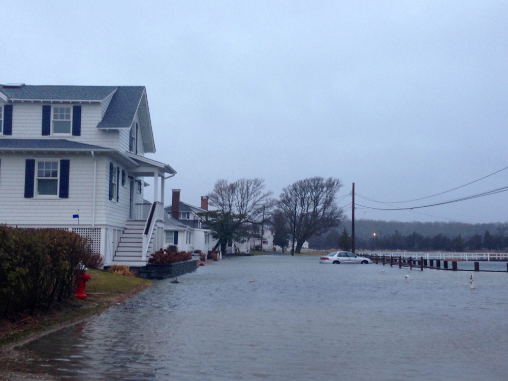
Update (Tuesday 5 p.m.): Areas along the shoreline, including several properties in New Suffolk, are being inundated by coastal flooding as a early winter nor’easter moves across the North Fork.
But the Southold Town Highway Department hasn’t had to close any road due to flooding or trees falling, said Highway Superintendent Vincent Orlando.
Mr. Orlando said the department’s workers have mostly been “puddle jumping” between flooded roadways, pumping out the rainwater before the roads become impassable.
“We’ll be down here ’til close to midnight,” he said. The department hasn’t had a single report of a tree falling on a town road, he added.
“We lucked out on that one,” Mr. Orlando said.
Update (Tuesday 10 a.m.): Hazardous weather advisories remain in effect Tuesday as a nor’easter brings heavy rain and strong winds to the area.
Southold Town Highway Department crews prepped for the nor’easter by readying tree and branch removal equipment Monday afternoon, Highway Superintendent Vincent Orlando said.
Payloaders, chain saws and backhoes were tested through the day in anticipation of heavy rain and wind downing trees in Southold, Mr. Orlando said.
“It is so when trees come down we can get out there and react quickly,” he said.
As of Tuesday morning, PSEG is reporting fewer than five outages in the hamlet of Southold. Crews have been dispatched and officials expected power to be returned by 11 a.m. Across the island, there are nearly 300 customers without power, according to PSEG.
By the time the storm tapers off Tuesday night, the area is expected to have received two to three inches of rain, though the poor weather could stick around through Thursday, according to current forecasts.
-CYNDI MURRAY
Original Story (Monday): The North Fork should dodge any wintery weather from a nor’easter hurling up the coast late Monday, but the storm is still expected to pack high winds and heavy rain, weather experts say.
The National Weather Service will issue watches for coastal flooding, high winds and storms for the area starting Tuesday morning, said meteorologist David Stark.
“We’re going to be dealing with a developing nor’easter moving up the coast tonight,” Mr. Stark said.
A few scattered flurries Monday afternoon were the very edge of the weather system.
Light rain is predicted to begin tonight, Monday, and build in intensity through the overnight hours, he added. By morning and through Tuesday afternoon, the storm may bring “moderate to heavy” rains totaling up to three inches, according to the forecasts.
Beginning Monday night, winds could gust up to 50 miles per hour, Mr. Stark said. Local waters could see even heavier winds, potentially “just under hurricane force,” he added.
By Tuesday night, the rain should begin to taper off, though the poor weather may linger, according to current forecasts.
“This system might be with us meandering through the New England coast through Thursday morning,” Mr. Stark said. “It’s just going to take some time to move out.”
As of Monday afternoon, the storm watch for local waters will run from 1 a.m. to 6 p.m. Tuesday, a high wind watch will run from 6 a.m. to 6 p.m. and the coastal flood watch will be in effect from 11 a.m. to 2 p.m.


