


NWS: Some rain may mix in with storm, but heavy snow still expected

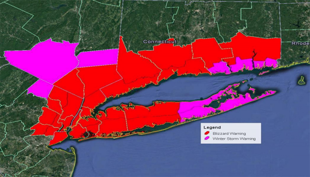
The winter storm bearing down on the North Fork Tuesday may switch over to rain for brief periods tomorrow afternoon, causing the National Weather Service to cancel the blizzard watch. A winter storm warning, however, remains in effect starting at midnight Tuesday, the NWS said.
“It’s not exactly good news,” Melissa Di Stigna, a meteorologist for the NWS in Upton, said of the change from blizzard watch to winter storm warning. “The reason it changed is the storm may track a little farther west. Some brief periods of rain will probably slice in with the snow.”
The East End, according to an updated weather advisory issued just after 4 p.m. Monday, is predicted to receive 8 to 12 inches of snow.
“It’s still not going to be a very good day to be out and about,” Ms. Di Stigna said.
The forecast could still potentially see some changes before the storm hits. In a conference call Monday afternoon, Suffolk County Executive Steve Bellone said they’re “hoping for a more wintery mix on the East End,” while the western portion of the county seems likely to have more than a foot of snow at least. A blizzard warning is in effect for most of the county west of the William Floyd Parkway and anywhere from 12-24 inches of snow is predicted.
The winter storm warning calls for heavy snow with possible blizzard conditions Tuesday morning with snowfall rates of 1 to 2 inches per hour early in the morning. The storm is expected to last through the day Tuesday before clearing out late at night.
“We are on track for what is really a massive storm, a storm that is potentially dangerous given the conditions that are expected,” Mr. Bellone said.
Damaging winds are also possible. The NWS said a northeast wind of 30 to 40 mph is expected with gusts up to 60 mph. The temperature will hover around 30 degrees and visibility will be one-quarter of a mile or less at times.
A coastal flood advisory is also in effect from 11 a.m. to 4 p.m. Tuesday. Minor to local moderate coastal flooding is expected around the time of high tide late Tuesday morning into Tuesday afternoon, the NWS said. Mr. Bellone said high tide for Riverhead and Peconic River is 2:07 p.m.
Mr. Bellone encouraged residents to avoid driving if possible. Strong wind combined with heavy snow will likely create white-out conditions in the morning that make it difficult even for plows to navigate, Mr. Bellone said.
“It’s very important that people are not traveling tomorrow unless they absolutely have to,” he said. “The road conditions, I would describe, based on the prediction of the storm, to be treacherous.”
At 5 p.m. today, the county’s website will be updated as an emergency page with contact information residents may need during the storm. Residents can also sign up for a Code Red emergency notifications on the website to receive text message updates.
Governor Andrew Cuomo declared a state of emergency across all 62 counties and directed non-essential state employees impacted by the winter storm to stay home from work on Tuesday.
“With heavy snow and blizzard-like conditions expected from upstate to downstate, we are taking every precaution to keep New Yorkers safe,” Mr. Cuomo said in a statement. The Capital Region of the state is expected to be hit hardest with 20 to 24 inches of snow.
Mr. Bellone said he expects a state of emergency to be issued at some point when the storm hits. Riverhead and Southold towns typically issue their own state of emergencies during these types of storms as well. Greenport Village asked residents to remove their cars from the roads.
Village Hall will be closed Tuesday and the Southold Town Board work session and town board meeting were both postponed to next week.


