


Closer Look: King tides offer climate insight

Sky-gazers enjoyed a rare sight Sunday as a supermoon coincided with a total lunar eclipse. The syzygy of Earth, the moon and sun caused the celestial phenomenon, but also brought unusual tidal patterns. These tides — the highest and lowest of the year — are colloquially known as the king tides.
“It’s at a time where the Earth is actually a little bit closer to the sun, and you have the Earth, sun and moon all aligned. It’s that little extra boost,” said Peconic Baykeeper Peter Topping ahead of a high-tide flyover of the twin forks Wednesday morning.
King tides also provide a harrowing glimpse into what will one day become a coastal reality due to rising sea levels.
“They’re predictable events which allow for observation time to observe, basically, a snapshot of what could and is likely to happen in the future with sea level rise,” Mr. Topping said.
For most people, seeing is believing in terms of climate change.
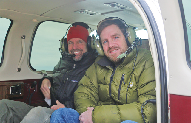
LightHawk Conservation Flying uses flight missions to document king tides and raise awareness about climate change.
“King tides are a perfect scenario in which to model how water levels may impact infrastructure originally placed in low-lying areas,” said Jonathan Milne, eastern program director at LightHawk.
The group organized 25 flights on both coasts, including Long Island, to document how they will be affected by higher tides.
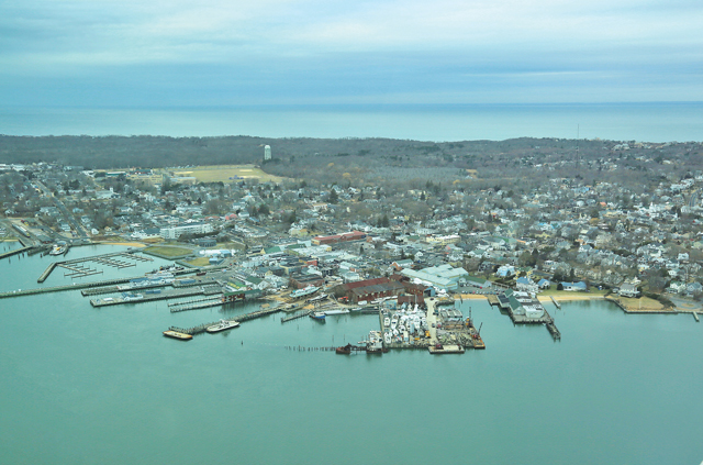
On Long Island, the flyover provided a bird’s-eye view of the roads, utilities and tidal areas at risk.
Along the south shore, seawater flowed past its usual boundaries, spilling over across low-lying areas. After hooking around Montauk Point, LightHawk pilot Joseph Fischetti headed north to Orient, which sits at approximately 10 feet above sea level.
“You can see just how low Orient is,” said Mr. Fischetti of Southold.
Taking the predictions for sea level rise on Long Island into account presents an alarming visual. The New York State Department of Environmental Conservation’s “medium” projections are six inches by 2020, 16 inches by 2050, and 29 inches by 2080.
“The time to prepare is now. It would have been better even 20, 30, or 40 years ago. I find it somewhat alarming when I see some of the development going on,” Mr. Topping said.
Most waterfront property owners use bulkheads as protection, which has actually exacerbated erosion.
“You can go the natural way, or if you’re lucky enough to have the property, set things back. The other option that pretty much no one wants to talk about, especially if you’ve had a house for a really long time, is retreat,” he said.
In East Hampton Town, officials are debating moving Montauk’s downtown area inland in response to sea level rise.
“They give us a picture into what daily water levels could look like as the whole ocean rises. That’s why more and more, we observe them and look at them,” said Peconic Estuary Program director Joyce Novak.
The main thing Long Islanders can expect is a higher baseline sea level.
“You can imagine the two forks of Long Island kind of being a catcher’s mitt for water,” Mr. Topping said. “In those back creeks in the Peconics, what might only be a few inches somewhere else can actually pile up a bit more dramatically.”
In his new role at the Peconic Baykeeper, Mr. Topping is focused on water quality, which has been adversely impacted by nitrogen entering waterways.
Impacts aren’t just limited to rising seas, but warmer ones, too. “Warmer water temperatures can fuel bigger storms,” Mr. Topping said. “And we’ve been seeing more and more of those.”
Living shoreline projects are one way to mitigate the impacts of rising sea levels, Ms. Novak said. A living shoreline can stabilize coastlines by using natural materials — native grasses, mussels, clams, rocks — to better handle higher tides and inflowing water.
“If you build a bulkhead right against the water, you’re just gonna have to keep building that bulkhead higher,” Ms. Novak said. “With a living shoreline buffer on the seaward side, you have the ability for that water to be managed and dissipated along the shoreline instead of directly up and into it.”
The Peconic Estuary Program can help the five East End towns access grant money for such projects. Two are in the works for Southold Town, Ms. Novak said.
Early in his career, Mr. Topping taught marine science to children. An activity he used to do was have them look at the beach, close their eyes, wait 30 seconds and open them again.
“I’d say ‘What do you see?’ and they’d say ‘I see the beach.’ But it’s not the same beach. This is a dynamic system. We’re not gonna stop the ocean … on a personal, federal and global level we need to plan for this as something that’s happening in real time.”


