Plan presented to add flood protection to Orient’s Narrow River Road

A wetlands restoration project proposed for Orient could turn Narrow River Road into a recreational path for residents.
It’s one of four recommendations outlined in a conceptual design plan funded by the Peconic Estuary Program in a partnership with Ducks Unlimited and Southold Town.
The plan, released Tuesday, aims to improve tidal flow in a 75-acre area that encompasses Narrow River, a tributary of Peconic Bay that flows south from the Whitcom Marsh Preserve under Route 25, as well as an area north of a man-made dam known as Broad Meadows. The marsh areas were historically used for duck hunting but have since been consumed by invasive phragmites.
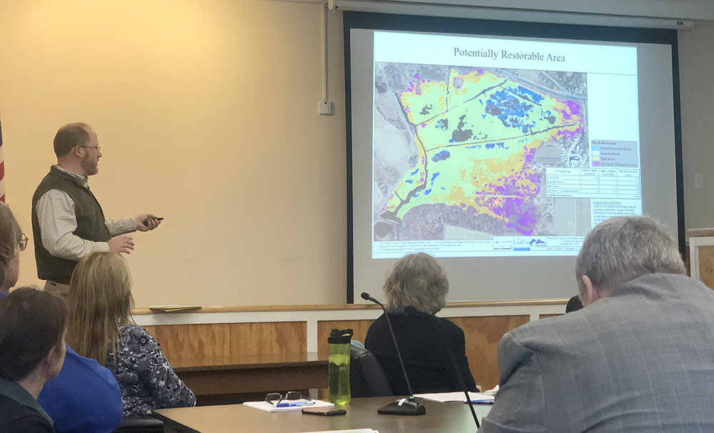
“We want to restore the habitat and also provide resiliency and flood protection as well,” PEP state coordinator Elizabeth Hornstein explained Tuesday during a Town Board work session.
The Great Hurricane of 1938 prompted construction of the original dam, “because that was so devastating to the farmland in Orient,” according to John Sepenoski from the town’s geographic information systems. Over time, culverts that are no longer functioning properly were added to the system. “[At low tide,] you’ll hear a garden hose-level trickle,” Mr. Sepenoski said. “We are artificially keeping way more water up in Broad Meadows than otherwise.”
The recommendations include replacing culverts with self-regulating tide gates to promote tidal exchanges, using fill from that installation to plug a farm ditch and mitigating the culvert at the Route 25 crossing to promote water flow and fish passage.
Officials believe that increasing the salinity of the marshlands will, in turn, help eradicate phragmites and encourage the regrowth of native vegetation and an increase in waterfowl and habitats.
Removal of the berm and culverts, Ms. Hornstein said, would pose flooding risks to adjacent farmland and, potentially, Route 25.
Jim Feaga, a regional biologist with Ducks Unlimited, gave an overview of the proposed projects during the work session, adding that there are two options to mitigate persistent flooding on Narrow River Road itself.
The first would involve raising a roughly 400-foot section of the roadway to keep it above the mean higher high water mark as sea levels rise.
The second option would convert the roadway into a pedestrian and/or bike path, which officials say could eliminate road maintenance costs and provide recreational opportunities for residents. A portion of the roadway’s northern end, which has a higher elevation, could be converted to a parking lot, Mr. Feaga said.
Mitigation measures for Narrow River Road were based on research that found it will become more vulnerable to storm surges and increased routine tidal flooding in the coming decades due to sea level rise.
The PEP plan used both regional projections established by a 2010 NYSERDA ClimAID study, which anticipates that seas will rise by seven to 12 inches and 12 to 23 inches by the 2050s and 2080s, respectively, and local projections for eastern Suffolk County based on NOAA data, which puts sea level rise on a much more aggressive track, predicting 24 to 36 inches by the 2050s.
“In either case, Narrow River Road is going to have to be addressed at some point due to the sea level rise conditions,” Mr. Feaga said.
Town Board members overwhelmingly supported moving the project forward, which Mr. Sepenoski said would require identifying funding sources, such as grants. He also asked the board whether they’d consider using Community Preservation Fund money to complete portions of the project since they impact water quality.
Such a measure would be subject to a public hearing, he said.
A public meeting and presentation on the conceptual plan has been scheduled for noon Friday, Nov. 22, at the Peconic Lane Recreation Center.
Photo caption: The Southold Town Board views a presentation at Tuesday’s work session. (Credit: Tara Smith)