
Southold wireless service plan available for public input

A wireless communications plan for Southold that identifies strengths and weaknesses of local wireless connections is now available for public review. The town will gather feedback about the plan through a virtual poll on the town’s website over the next three weeks.
The report prepared by CityScape Consultants, a wireless consulting group based in Palm Beach County, Fla., evaluated cell phone service coverage throughout Southold and proposed strategies to improve service.
There are currently 16 wireless facilities in Southold Town, according to the infrastructure assessment conducted in October 2024. Three other wireless facilities fall outside the town’s zoning jurisdiction, two of which are located in the Village of Greenport. Six of the town’s 16 wireless towers support public safety equipment.
Two sites on Shelter Island help supplement coverage west of East Marion and extend service toward commercial areas in Greenport and central Southold. Fishers Island has one wireless facility at a church steeple on Alpine Avenue which supports one wireless service provider.
“Although these towers are generally well distributed and provide a solid foundation for commercial coverage, they are not sufficient on their own to support a high performing, long-term wireless network,” the plan states. “Additional sites will be necessary to expand coverage, increase capacity and to meet the seasonal demand placed on the existing network.”
According to the 2020 Census, Southold’s population is 22,732. That number swells significantly in the summer and holiday seasons because of tourism and second-home occupancy.
The minimum usable coverage level identified in the study was “adequate” for outdoor coverage but “insufficient” for reliable indoor or in-vehicle service. The typical minimum coverage level for dependable outdoor coverage was identified as “strong enough to support reliable calls, texts and data sessions.”
The wireless coverage prediction maps use a color gradient ranging from yellow to blue to indicate varied levels of signal strength emanating from each wireless service facility.
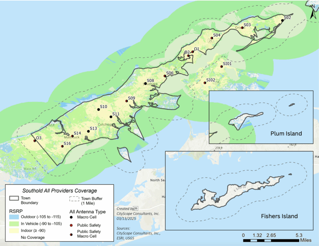
Yellow areas identify the strongest signal coverage for both indoors and outdoors; green areas indicate moderate signal strength; blue areas represent weaker signal strength that may be sufficient for basic outdoor connectivity; and unshaded portions represent areas with marginal, spotty or lack of signal.
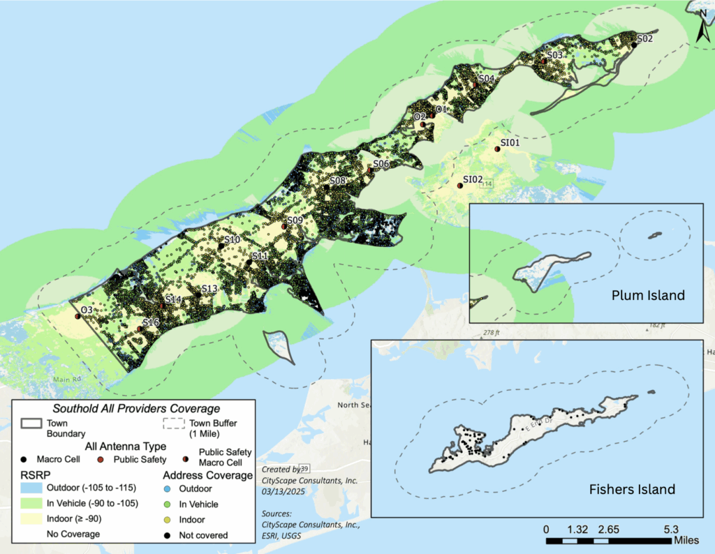
A second map shows the wireless connectivity indoors at address points throughout the town. Factors that can contribute to signal strength obstruction include terrain elevation, tree canopy density, vegetation, or the construction materials and architectural design of a building itself.
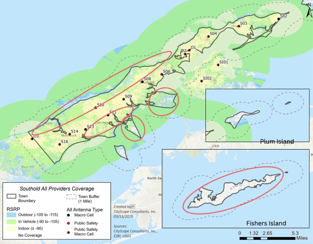
Gaps in coverage exist along the northern shoreline, where portions of waterfront service are weak or nonexistent due to terrain limitations and distance from existing infrastructure. Peninsulas along the southern shoreline have little to no coverage, because no wireless facilities currently serve those areas.
When considering solutions to the coverage gaps, the plan calls to prioritize optimization of existing facilities; factor in seasonal population variation to handle peak usage periods; plan for long-term deployment of faster, higher-frequency wireless technology like 5G and 6G; consider antenna type selection; and preserve the town’s views by avoiding industrial-looking utility structures in scenic or sensitive areas.
Environmental constrains — such as Southold’s designated flood zones, coastal erosion hazard areas and state-regulated wetlands — limit placement opportunities for the installation of new wireless towers or base stations. Community characteristics and zoning preferences will also influence the placement and design of wireless infrastructure.
Two simulated engineering solutions for coverage gaps were developed for a potential comprehensive 10-year wireless strategy in Southold Town. The simulations offer guidance for long-term infrastructure planning.
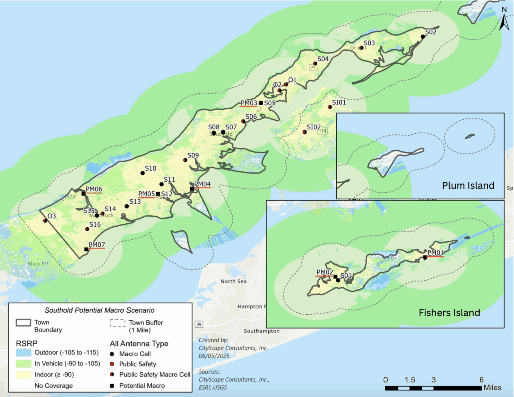
The first scenario proposes five new macro cell antennas that offer the most flexibility and coverage range for wireless service providers. The antennas are typically mounted on taller towers or structures to maximize elevation and signal reach, but can be harder to visually conceal.
The “macro-site” scenario also suggests the replacement of a 80-foot utility pole with a 120-foot tower and a redesign of a currently proposed 145-foot tower at the Cutchogue fire station with a 160-foot tower. It also calls to increase the height of an existing 145-foot tower to 199 feet for higher antenna placement and better signal reach.
Two proposed macro sites for Fishers Island in that plan could improve in-vehicle and partial indoor coverage across nearly the entire island.
However, local zoning constraints on maximum antenna height present challenges for this first scenario.
Scenario two calls for small cell wireless facilities installed within public right-of-way on new, replacement or existing utility poles. This method could increase network capacity or improve wireless coverage in areas where macro cell sites are limited by zoning constraints or potential signal interference.
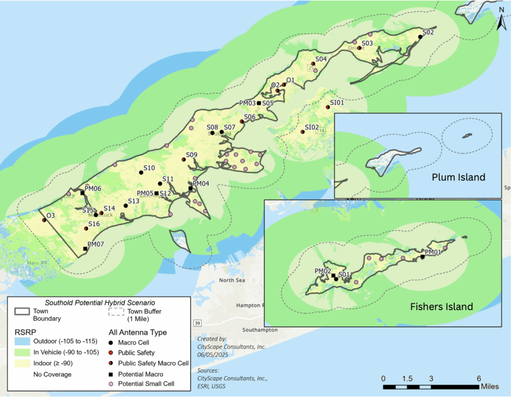
The second scenario would build on a network of five potential macro cell antennas, introducing 28 potential 45-foot small cell locations — five of which would be located on Fishers Island.
Both the master plan and the poll results will be used to create a new zoning code to incentivise cell carriers to improve service in the area, whether it be through new or improved cell towers, small cell technology, or a combination of both.
The survey takes roughly 15 minutes to complete and asks questions about residency, wireless cell phone usage, cell phone provider subscription information, WiFi reliance, and strength of cell service at home, work or when traveling in Southold. It also asks which cell tower facilities residents would support being constructed in Southold with pictures of those towers.
To participate in the Southold cell service survey click here.
Following the public feedback period, a regulatory review will be conducted before a final plan is released.