
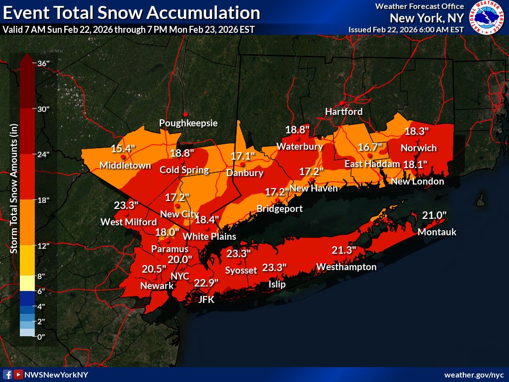
Snowfall updated to 16 to 23 inches prompting school, business closures
Area businesses and libraries are taking to their social media feeds Sunday morning to communicate cancellations and closures ahead of the blizzard warning that begins at 1 p.m. today.
The latest update from the National Weather Service added a Hazardous Weather Outlook for southeast New York that includes the blizzard warning unchanged from 1 p.m. today to 6 p.m. Monday and a coastal flood warning from 10 p.m. tonight until 6 a.m. tomorrow.
Snow totals have increased to 16 to 23 inches. It’s forecasted to begin after 4 p.m. today and increase overnight with 11 to 17 inches accumulating by Monday morning. It is expected to continue to fall until 4 p.m. Monday with another 3 to 7 inches accumulating.
Suffolk County issued a travel ban starting Sunday at 9 p.m. until Monday at 9 p.m. The Town of Southold also declared a state of emergency, effective Sunday at 4 p.m. until Tuesday at 5 p.m.
Southold, Greenport, Mattituck-Cutchogue and Oysterponds schools announced they will be closed on Monday due to the weather.
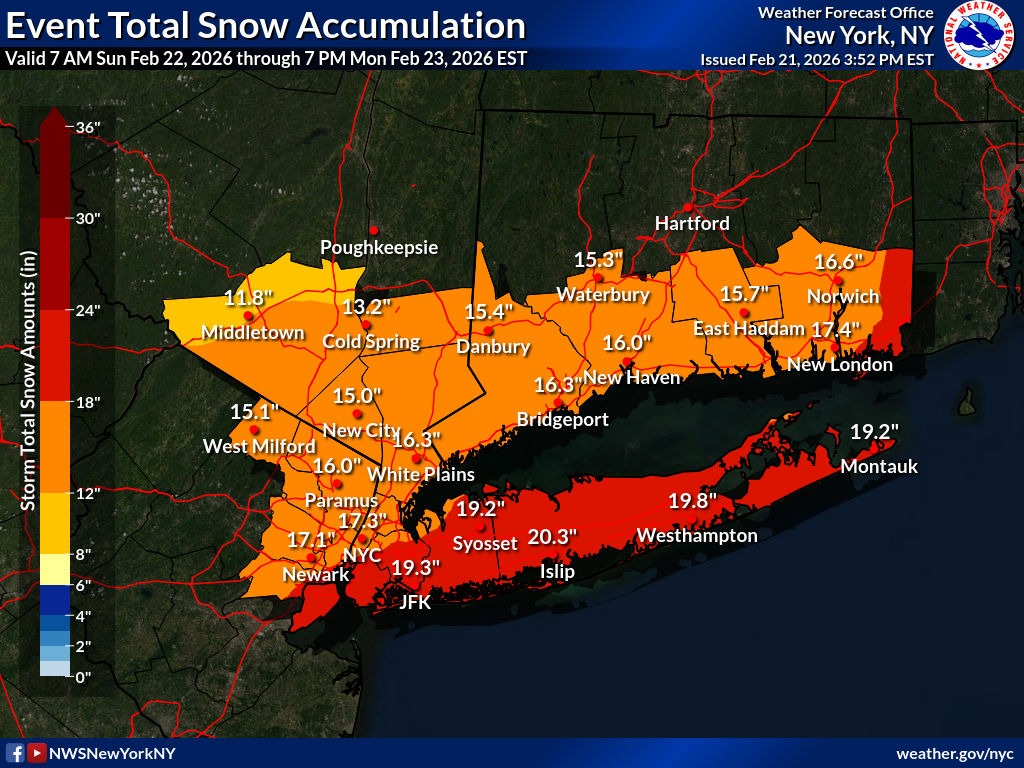
Posted Feb. 21, 10 p.m.: State of emergency declared, snow totals updated to 15 to 20 inches
Southold Town Supervisor Albert Krupski Jr. declared a State of Emergency until 6 p.m. Monday, Feb. 23 ahead of the blizzard warning.
Residents are urged to continue monitoring local weather conditions, avoid unnecessary travel, and assist in keeping roadways clear by removing vehicles from town rights-of-way. Non-essential town offices will be closed on Monday, Feb. 23.
The National Weather Service updated the snow totals to 15 to 20 inches of snowfall for the North Fork. The blizzard warning timing was also shifted and is in effect from 1 p.m. Sunday to 6 p.m. Monday. The wind gust forecast has also increased to as high as 55 mph with isolated gusts up to 60 mph, however, gusts on the east end of Long Island could reach 65 mph, according to the NWS.
Report power outages by calling PSEG at 1 800-490-0075 or visiting their website.
In case of an emergency, dial 911. If you have any non-emergency questions, call the Southold Town Police Department at 631-765-2600.
Blizzard warning issued Saturday, Feb. 21, 13-18 inches of snow
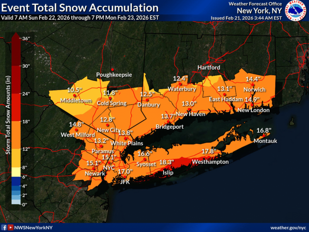
UPDATE: Winter storm watch upgraded to blizzard warning from 6 a.m. Sunday to 6 p.m. Monday for Long Island. Falling and blowing snow with strong winds are likely, with the forecast increased to 13 to 18 inches of snowfall. This will lead to whiteout conditions, making travel extremely dangerous.
There is also a Coastal Flood Watch in effect from Sunday evening through late Monday night, which could inundate areas near the waterfront and shoreline with 1-1/2 to 2-1/2 feet of water.
According to the National Weather Service Gardiners Bay at Orient Point may see breaking surf of 4 to 8 feet, causing beach flooding and dune erosion during high tide times of 1:06 a.m. and 1:18 p.m. Sunday.
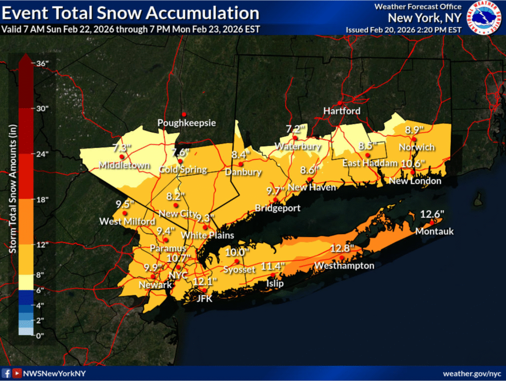
Winter storm watch Friday, Feb. 20, 10-13 inches of snow
Lace those boots back up, North Fork, because it looks like snow is on its way again this weekend.
The National Weather Service issued a winter storm watch for Long Island from Sunday morning through Monday afternoon. It warns of blizzard conditions, and that total snow accumulations could be between 10 and 13 inches. Winds gusts could also be as high as 45 miles per hour.
Southold Town Highway Superintendent Dan Goodwin said the department is getting ready for the impending nor’easter, and that after this winter, they’re “pretty good at it.”
“We have our typical truck hooked up and salt and sand mixed, and everything’s ready for the big dance, so to speak,” he said. “We went through everything again today and just made sure that we were in as good a position as possible.”
Mr. Goodwin said the storm has been “trending up” throughout the last few days, and that it will be an “all hands and all personnel available” response.
The North Fork has been blanketed by a lot of snow this winter. Communities had to deal with the region’s largest snowfall since the blizzard of 2022 last month. The highway department worked throughout the duration of the last storm, and had 35 people working to keep streets clean and machinery working.
“We have materials on hand to deal with this, but we’ll obviously want to replenish our supply, because we do have several more weeks to go,” Mr. Goodwin said of the winter season. “We also have winter on the back end of the year, as well, that we might have to contend with.”
PSEG Long Island said the storm could be strong enough to topple trees, bring down branches on wires and cause power outages.
“We continue to monitor this weather system and have performed system and logistic checks to ensure any customers who may be affected will have their power restored safely and as quickly as possible,” said Michael Sullivan, vice president of Electric Operations at PSEG Long Island.