
Over 10 inches of snow possible across North Fork Sunday into Monday
Lace those boots back up, North Fork, because it looks like snow is on its way again this weekend.
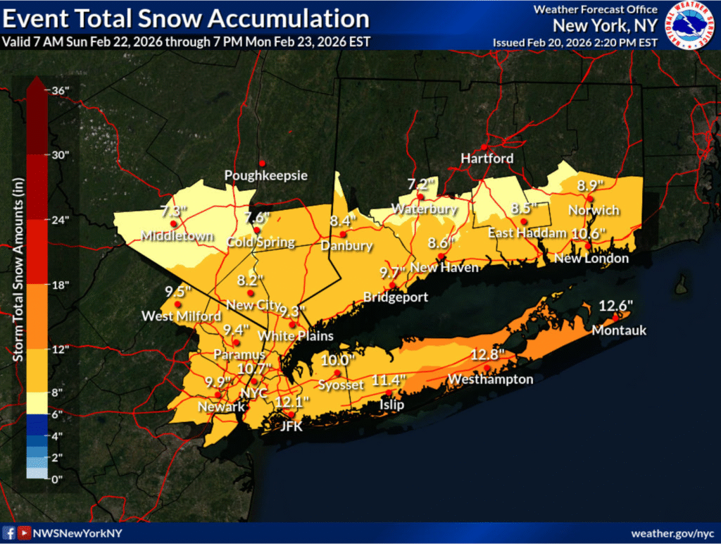
The National Weather Service issued a winter storm watch for Long Island from Sunday morning through Monday afternoon. It warns of blizzard conditions, and that total snow accumulations could be between 10 and 13 inches. Winds gusts could also be as high as 45 miles per hour.
Southold Town Highway Superintendent Dan Goodwin said the department is getting ready for the impending nor’easter, and that after this winter, they’re “pretty good at it.”
“We have our typical truck hooked up and salt and sand mixed, and everything’s ready for the big dance, so to speak,” he said. “We went through everything again today and just made sure that we were in as good a position as possible.”
Mr. Goodwin said the storm has been “trending up” throughout the last few days, and that it will be an “all hands and all personnel available” response.
The North Fork has been blanketed by a lot of snow this winter. Communities had to deal with the region’s largest snowfall since the blizzard of 2022 last month. The highway department worked throughout the duration of the last storm, and had 35 people working to keep streets clean and machinery working.
“We have materials on hand to deal with this, but we’ll obviously want to replenish our supply, because we do have several more weeks to go,” Mr. Goodwin said of the winter season. “We also have winter on the back end of the year, as well, that we might have to contend with.”
PSEG Long Island said the storm could be strong enough to topple trees, bring down branches on wires and cause power outages.
“We continue to monitor this weather system and have performed system and logistic checks to ensure any customers who may be affected will have their power restored safely and as quickly as possible,” said Michael Sullivan, vice president of Electric Operations at PSEG Long Island.